Geography of Ancient Bharat and the Significance of Rivers and Mantras
Our dharmic shlokas and our holy river system are the key focus of this paper. I have emphasised on some of the shlokas from the Dharmic literature and tried to explain its meaning, by highlighting the link to the unity of Bharat and the fact that our holy rivers are the support system on which our civilizations flourished.
I have tried to highlight the links of the geography through the Ramayana and Mahabharata followed by the glorious Indus Saraswati Civilization and then followed by a series of glorious indigenous kingdoms which included Maurya, Chola, Vijayanagara, Ahom and Kalinga.
My claim in the paper is that shlokas and the rivers acted as two robust pillars to the indigenous civilizations in the past and are still important part of Bharatiya culture. However, eventually by the passage of time we lost the focus on understanding the meaning behind these shlokas and reciting them became only as a routine. On the other hand, rivers faced climate change and man-made exploitation the result of importance to personal gains. Further, I would also claim that our shlokas are the Bharatiya methodology of cartography which never evolved, as it was ignored just to reject the orthodoxy. Thus, we became victim of invasions due to the lack of focus on this indigenous science.
Introduction
Cartography is the science of drawing maps and has always been a western science for Bharat. We never had researchers drawing maps to portray our geography. To mention an example of the western cartography, I must admit I am impressed by the Text Book of Indian History by George Pope. The title mentions history but then, it accompanies a detailed description of geography of British India. This book and many others by the western researchers, was one of the reasons why British ruled so long. Probably this is one of the reasons as to why we have a colonial influence on the geography we learn today.
In most post-colonial theories, we have come across portrayal of Bharat as a geographical continuum which got created due to imperial Britain. Our world view was and is still infected with the western concept of nationhood, but if we look at it differently it was a civilization and not a nation. These theorists ignore the many facets of Bharat which depict the unity of the country and signify that it is not just a land mass. So, personally I don’t see Bharat as just a nation state but, an endless link of people, culture and borderless unity. We can link the unity of Bharat to a variety of topics, however one of the important points which I would like to focus on is about the importance of Rivers in ancient Bharat and the transfer of knowledge in the form of mantras.
Bharatiya Cartography
The foundation of Bharatiya culture is based on the motto of “milking the nature and not exploiting it”. The same is conveyed through the below shloka,
समुवसने देव पवततनमडले ।
वणुपिन नमतुयं पादपश मवमे ॥
The Devi who is having ocean as her garments and mountains as her bosom
Who is the consort of Sri Vishnu, I bow to you, please forgive me for touching you by my feet.
This morning shloka from the Dharmic literature recited by many across the world signifies the respect and devotion towards the nature by seeing the mother nature as Devi (Goddess). It depicts the approach of our sages who wrote these shlokas and what they wanted to convey to the people.
When we say rivers, I would like to start with the morning shloka recited by many across the world.
गंगा संधु सरवत च यमुना गोदावर नमदा ।
कावेर शरयू महेतनया चमवती वेदका ।।
ा वेवती महासुरनद याता जया गडक ।
पूणा: पूणजलै: समुसहता: कुवतु मे मंगलम् ।।
Oh, River Goddess Ganga, Sindhu, Saraswati,
Yamuna, Godavari, Narmada, Cauvery,
Sharayu, Mahendratanaya, Chambala, Vedika,
Kshipra, Vetravati, Mahasurnadi, Jaya and
Gandaki along with the sacred sea, shower blessings on me.
I have been hearing this shloka since my childhood, from my grandparents. However, I understood the significance of the shloka only when I questioned on why should I recite this? Is it only because, it’s a ritual or there is a meaning behind it. I feel it reflects the unity of India, depicts the culture of worshiping the life giver and conveys a story through it. If we go by the literal translation of the mantra, it seeks for blessing from the rivers of Bharat. We observe in the mantra that, irrespective of the location, the rivers are considered holy and eventually become one when they complete their journey and meet the Sagara (Indian Ocean).
The entire geography of Bharat is covered through this mantra right from the north to the south and east to the west. It reflects the geography starting from the Himalayas at the top and covering the entire area above the Indian Ocean which is the Indian Subcontinent as we call it now and the Akhand Bharat as Swatantryaveer Sawarkar connoted.
A reference to the Vishnu Puran gives us a description of the geography of Bharat which states,
उरं यसमुय हमाेचैव दणम् ।
वष तदारतं नाम भारती य सततः ।।
The country that lies north of the Ocean and south of the Himalayas
That is the land of Bharat, where the children of Bharata reside.
To continue with the Vishnu Puran, another shloka describes the mountains in the land of Bharata which says,
महेो मलयः सयः शुितमानृपवतः ।
वयच पारयाच सा कुलपवताः ।।
The shloka includes the description of chain of seven mountain ranges in Bharat which are; Mahendra, Malaya, Sahya, Suktimat, Riksha, Vindhya and Paripatra. Linking the shloka to today we can infer that it includes the eastern ghats & western ghats, Nilgiris, Sahyadris, Aravalis, Satpura and finally the Vindhyas thereby covering the entire modern day Indian subcontinent.
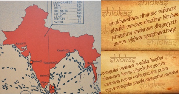
Map of Akhanda Bharat: 1
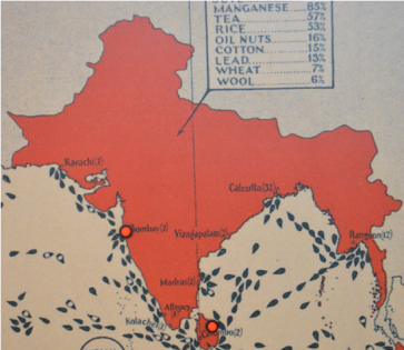
Akhand Bharat map displayed in the war museum in London (personal collection of the author).
Moving on to the Jyotirlingas, the below shloka gives the geographical locations,
सौराे सोमनाथं च ीशैले मिलकाजुनम् ।
उजययां महाकालं ओकारममलेवरम् ।।
परयां वैयनाथं च डाकयां भीमशकरं ।
सेतुबधे तु रामेशं नागेशं दाकावने ।।
वारणयां तु ववेशं यबकं गौतमीतटे ।
हमालये तु केदारं घृनेशं च शवालये ।।
एतान योतलगान सायं ातः पठेनरः ।
सतजमकृतं पापं मरणेन वनयत ।।
This shloka describes the geography of Bharat. The general belief is that there is a total of 50+ jyotirlingas however, the important ones are described in the above Shloka which again determines the same geography which we saw earlier in the shlokas of the Vishnu Puran. The places mentioned in the shloka are located across Bharat covering, South with Ramnathaswamy in state of Tamil Nadu & Mallikarjuna in Andhra Pradesh, moving to the west there is Somnath, Trimbakeshwar, Grushneshwar, Parali-Vaijanath, Bhimashankar, Aundha Naganath. In Central and East Bharat, there is Mahankaleshwar, Vaidyanath, Omkareshwar & Mamleshwar. And finally, the North is blessed with Kedarnath in Uttarakhand and Kashi Vishwanath in Uttar Pradesh. The shloka focuses on specifying these places, thereby telling the geography of the Bharat or Bharata Varsha as is called in the Puranas.
Following the mention of Jyotirlinga, we now move to the Shakti Peethas in Bharat. It is believed that the Shakti Peethas reside alongside the Jyotirlinga and thus we have the similar number of Shakti Peethas. The Shakti Peetha are located at the extremes of the modern Indian Subcontinent. To the west we have the Hingula Shakti Peetha located on the banks of Hingol River in Baluchistan province of Pakistan. To the east we witness, Tripura Shakti Peetha in Tripura & Trisrota Shakti Peetha located on the banks of river Teesta in West Bengal. Again, to the east we have a few in the modern state of Bangladesh, to mention a few of them, Sugandha Shakti Peetha located on the banks of river Sunanda & Chattala Shakti Peetha located on top of Chandranath Hill.
When we look at south we observe Shakti Peethas at various locations in the modern Indian states of Tamil Nadu, Andhra Pradesh, Srishaila Shakti Peetha located on top of Nallamalai Hills, Godavari Tir Shakti Peetha at Rajahmundry, Devi Kanyakumari Shakti Peetha located at Kanyakumari. To the extreme south barring the current geographical jurisdictions we have one in Sri Lanka by the name Lanka Shakti Peetha.
We observe the same in the north, where irrespective of the current country jurisdictions we have Shakti Peethas in Tibet, in Nepal and in the current Indian jurisdiction. The names of Shakti Peethas in the north are, Nepala Shakti Peetha located on the banks of River Baghmati, Manasa Shakti Peetha in the region of Manasarowar lake in Tibet, Gandaki Shakti Peetha again in Nepal located at the banks of river Gandaki.
Through all these shlokas and many more in the Dharmic Literature our sages had created the Bharatiya methodology of cartography which was not by drawing maps on paper but, by conveying the geography of Bharat Varsha in the form of shlokas. I consider this to be our long-lost science, because though we remember and recite these shlokas there is no curiosity in understanding the meaning of these shlokas. It is our failure that we could not make use of our Dharmic literature.
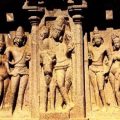
Moving on we will spend some thought on our pre-history and its link to the geography of Bharat. Due to the colonial influence, we often call our pre-history as mythology, however when we consider the references of the places in Ramayana or Mahabharata we realize it is in fact our pre-history. In Ramayana, the references to places like Ayodhya, Prayag (Allahabad), Chitrakoot, Nashik, Hampi, Rameswaram, then in the end Lanka. We see all these places had years of glorious civilizations supported by the very fact that all are located on the banks of the rivers. This chain of places is also known as the Dakshinpath (Southern Highway). As we see in Ramayana the depiction of the north-south connect, similarly we see in Mahabharata the focus on portraying the east-west connect. Both these chapters of pre-history occurred because of the civilizations created by the rivers. In a way rivers acted as messengers and medium of transport for the people in those times.
Ramayana
Various theorists have argued about actual existence of Ramayana and it is said that it was just larger than life story written by Rishi Valmiki. I won’t get into the debate on whether it was real or fiction, however I would mention a few points which signify its link to reality,
a) The Hampi was the place where Shri Ram and Hanuman met the first time later we know the Vanarsena joined Shri Ram in the battle against Ravana, we have seen references of a monkey king ruling this same place in both Ramayana and Mahabharata.
b) The references to the rivers Sarayu, Tamas, Ganga, Yamuna (Jamuna), Saraswati, Mandakini, Godavari and not to forget the great Hindu Sagar (Indian Ocean). These are still flowing barring a few which have become seasonal or as we say about Saraswati in hiding.
c) It is said that Ravana before becoming the king of Lanka was born in the Himalayas later migrated to the Kingdom of Kuber (Lanka) out of sheer attraction of the place and became the ruler.
d) There were various rulers in Bharat Varsha but, each had approachable relations and the same is visible in Sri Ram’s journey to Lanka. The feeling of being one country always prevailed.
Mahabharata
Mahabharata’s coverage is from the east to the west of the Indian Subcontinent with references to places like Gandhar (Kandhar, Afghanistan), Kurukshetra, Indraprastha (Delhi), Gurgaon, Hastinapur, Dwarka, Vrindavan, Mathura, Kashi, North East India, Ujjain, etc. Again, highlighting the geographical boundaries of the Bharat Varsha.
The points in Mahabharata which help us link it to today’s age are,
a) The Kingdom of Gandhar as we see references in Mahabharata to the Queen Gandhari who was the daughter of King of Gandhar. This place Gandhar is today’s city of Kandhar in Afghanistan. There have been references to the place in the Vedas.
b) Kurukshetra located in Northern India is the place where the battle of Mahabharata took place which is a small town in modern day Haryana.
c) Indraprastha was known to be the capital city of the Pandavas located on the banks of River Yamuna and is today’s city of Delhi.
d) Gurgaon the bustling new city as we know has a reference to it in the Mahabharata. It was the village of the Guru Dronacharya and thus the name Gurgaon (Village of the Guru).
e) Dwarka, Vrindavan & Mathura are linked to Sri Krishna.
f) There are references to places like Manipur where Arjuna marries Queen Chitrangada who is the daughter of the King of Manipur.
We see a geographical range from modern day Afghanistan to the North-East Region in Bharat. If we consider the Ramayana and Mahabharata as a sequence of events which happened in our prehistory, we see an emphasis on describing the geography of Bharat Varsha in addition to conveying the chronicle.
Civilizations and the Role of Rivers
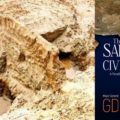
Indus Saraswati Civilization
One of the oldest civilization by the archaeological parameters is the Indus Saraswati Civilization. Over the period of excavations and studies we have a huge collection of information which relates to the civilization. The crux of this civilization are the rivers which flow in this geographical area many of them still flowing perennially while others lost in the way (Saraswati).
We have references of trade links with various other civilizations of the era to mention a few Magan (Yemen & Oman), Mesopotamia (Egypt), Central Asia etc. (Henceforth, we refer the people of the Indus Saraswati Civilization as the Harrapans). The Harrapans made use of the river system effectively for farming, trade, transport etc. We can infer that the river worship culture what we see on the banks of our rivers in today’s day and age is influenced from the Harrapans. If we consider the days of the civilization the geographical coverage is huge. In the north, it covers parts of Afghanistan and northern areas of today’s Pakistan (places like Takshashila / Taxila), to the south it stretches up to Saurashtra (Gujrat) even further down south up to the Dandakaranya (area below the north Maharashtra), to the east it almost touches the banks of the river Yamuna (Western Uttar Pradesh) and on to the west the archaeologists have found Harrapan sites in Baluchistan (Today’s Iran & Pakistan border).
Even by today’s standards with faster modes of transport we would take several days to cover this huge area, so the best mode of transport for the Harrapans must have been the rivers and the Hindu Sagar (Arabian Sea in the Indian Ocean). We must consider it the failure of our educational system that when anyone calls the name of Indus Saraswati Civilization / Indus Valley Civilization the first thing which comes to the mind is the excellent sewage system of the Harrapans. The question to ask is do we want to restrict the legacy of our ancestors to only sewage system?
Later in History we have many kings and various kingdoms which was the result of the Harrapan Civilization and their migration to the various parts of the Bharat. We had many illustrious kingdoms over the period in all directions of the Bharat, battling each other for the land, still the essence of being one nation was always there.
Maurya Empire
Chandragupta Maurya founded the Maurya Empire under the guidance of Chanakya / Kautilya (author of Arthashastra). The Maurya Empire had its capital at the banks of river Ganga at Patliputra (modern day Patna the state capital of Bihar). The Maurya Empire stretched from the modern Afghanistan in the north west, to the east up to Bengal to the south almost up to the southern tip of Bharat. Later in life Chandragupta Maurya accepted Jain religion and became a monk and moved to Sharvanbelagola in Karnataka. Here we observe the north south connect where the King of a northern kingdom gets inspired by monks in South and then decides to leave all his powers and possessions. Yet again we see the same geographical area under one rule.
It is said that the southern tip of the Chola Empire was not part of the Maurya Empire however, both these empires had friendly relations and trade ties which were based on strong river and ocean trade network.
Chola Empire
The founder of Chola Empire was Vijayalaya Chola. The capital cities of the Empire changed over the period however, the main location of the empire was in and around the banks of river Kaveri. The illustrious period in the Chola Empire is the reign of Rajendra Chola who expanded the kingdom to the South-East Asia and increased the Bharatiya influence in various parts of the world. Chola Empire had a strong navy and these naval expeditions were not just restricted to the East but, to the west as well with Maldives being an example. The trade was the major economic booster for the kingdom with trades to the west with Arabia to the east with South east Asia, covering a geography from modern day Morocco, Oman, Yemen to the west and Malaysia, Cambodia, Vietnam to the east.
Vijayanagara Empire
As a continuation to the strong Bharatiya influence we had the Vijayanagara Empire. Vijayanagara Empire as it is called is known by the capital city of the Empire which is the Vijayanagara which literally means the city of victory. This city is located on the banks of river Tungabhadra in the modern state of Karnataka. This Empire though restricted only to the southern part of Bharat is one of the glorious period in the history of Bharat. The founder of the Empire Harihara Raya and then an illustrious list of monarchs who ruled the empire.
Vijayanagara / Hampi has its reference in the Ramayana mentioned above. In its times Vijayanagara was one of the biggest cities in the world, which can be felt when we visit the modern-day UNESCO world heritage site at Hampi. The place is majestic and the visitor can imagine how big the city was in its times. We see a similarity in the structures at Hampi and the ones at the Harrapan sites. This again links the two and conveys the message of One Nation – Bharat.
Ahom Kingdom
The North-Eastern kingdom of Ahom founded by Sukaphaa. It covered the parts of modern day north eastern states and parts of modern day Myanmar. The kingdom was located on the banks of river Brahmaputra. Again, we see a kingdom emerging with the support of a river. The Ahom Kingdom ruled this area for almost 600 years later becoming part of the British India. Not much is known about the Ahom Kingdom again a defeat of the educational system of current state of India.
Kingdom of Kalinga
Prehistory (Mahabharata) has references to Kalinga. During Kharavela’s reign Kalinga became an illustrious empire and he was known as Kalingadhipati. It was during the times of the Maurya empire that in a battle between the two kingdoms (Kalinga War) this part was annexed with the Maurya Empire. The region covered is mostly the modern state of Odisha and some parts of Andhra Pradesh. Yet again we have the rivers Godavari and Mahanadi influencing the empires and creating & supporting the civilizations. We have historical references of trade relations between Kalinga and the South-East Asia (Bali). The tradition is continued till today, there is a festival named Bali Yatra which means journey to Bali and has its roots in the trade relations in the past. Celebrations start on Kartika Purnima and though there is no actual journey, children float toy boats in the river Mahanadi as a tribute to the past. All these civilizations and empires were at same or different points in time nevertheless, their approach was similar, of worshiping the rivers and not to forget the Hindu Sagar. All these kings and kingdoms were fighting against the invaders from outside the geography of Akhanda Bharat mentioned above.
In all the mentioned kingdoms and others, we observe trade boom through the rivers for inland connectivity and the Ocean trade through the Hindu Sagar and covered a vast geographical area from Morocco to Vietnam. Although there were many rulers the civilization was one and had no borders per se. We can conclude that the feeling of togetherness always existed in the land of Bharat.
Present Day
An important legacy from the Harrapans is river worship, which we have also seen in the various kingdoms over the years. The climatic conditions have changed and we observe depletion in our holy rivers; a frequently discussed example is of the river Saraswati. If we connect the dots we will see that the drying up of the unofficial Saraswati 2 bed led to migrations by Harrapans, to the various places across Bharat and further, we observe the name Saraswati to many other rivers in the country. We have three official Saraswati rivers and an unofficial one which is the Ghaggar. It shows that though migrations take people to different places still their river goddess shadows them and showers blessings on its devotees. But then, this is a way of consoling the pain of losing a rich civilization.
If we continue with the destruction of our rivers the way we have done till date, we will be forced to search for new ways to remember our holy rivers through some other medium like we did with Saraswati. If this goes on in no time we will have a long list of rivers who will accompany the holy Saraswati in the list of lost rivers and we would be forced to find ways to keep it alive in some other form. I am aware that it is not just the man-made destruction which led to extinction of Saraswati, but then we can at least avoid the man-made destruction & exploitation of our holy
rivers.
Being an agrarian society water is an important resource. In this age, we see the states quarrel over the use of resources, fighting battles in courts over the share of resources. Exploitation of water for individual interests, destruction of forest cover leading to lower rainfall and again impacting our river system. The change in climate, exploitation of natural resources and other reasons has led to the imbalance of resources across Bharat. We see droughts in some areas and floods in others.
Examples of man-made problems a way of exploiting the resources:
1. Sutlej river dispute: The Sutlej water dispute between the modern states of Punjab & Haryana is a case under litigation over the use of water from Sutlej River. This is exploiting the river resources for personal / political gains. This makes me feel we haven’t learnt anything from our past.
2. Cauvery river dispute: Another similar case between the modern states of Karnataka and Tamil Nadu is the Cauvery water dispute and has been a long drawn fight. A recent example of the flooding of the Brahmaputra resulting into havoc in the north-eastern region of Bharat and on the other hand, there are droughts in the south & central region of Bharat. These can be solved by the river linking project. The government has taken baby steps towards this direction by the recent linking of Krishna and Godavari, but then we need to support this initiative for a better tomorrow.
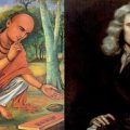
Today we have few new researchers doing a great service to the people by helping us understand the dharmic literature. I see this as their way of showing gratitude to our ancestors. However, it is such a huge ocean of information that a few researchers won’t be enough for the task.
Conclusion
As the saying goes, the best reason to learn history is to avoid repeating the mistakes from the past but, the question is, are we learning anything? Do we follow the foundation principle of, “milking of the nature & not exploiting it”? As mentioned earlier, rivers have always been an important pillar of Bharatiya culture. The river linking project mentioned earlier is the way of optimising our resources, thereby avoiding the clashes between the various states over the use of water from our holy rivers. This is help avoid the droughts and floods and thus bringing back the ecological balance.
Dharma teaches us to bow down to the nature and it is still considered to be an integral part of Bharatiya culture. Yet again we have forgotten the spirit behind the worship of nature. Due to our ignorance to the Shlokas, we have failed to progress in the science of cartography, which to my mind was the biggest advantage to the invaders. The new generation should be made aware of this long-lost science of Bharatiya cartography from our Dharmic literature. It is our responsibility to do our bit to improve the situation and spread awareness of the messages from the Dharmic literature. I will restate my earlier point, the shlokas are not just limited to the cartography but, it is an ocean of knowledge and a legacy from our ancestors.
Bibliography
1. The Lost River – On the Trail of the Saraswati by Michel Danino
2. The Land of Seven Rivers – Sanjeev Sanyal
3. The Puranas, Ramayana, Mahabharata
4. The Ocean of Churn – Sanjeev Sanyal
5. Text Book of Indian History – G U Pope
6. Map from the Museum Ship HMS Belfast – London, Wikipedia.
Featured image courtesy: idagunji.org 9shlokas).
Parikshit Gogate
Latest posts by Parikshit Gogate (see all)
Related posts:
 Sanjeev Sanyal: Narrating How India’s History was Shaped by Her Geography
 Uma Mohan: Musical Mantras in Sanskrit from the Vedas and Scriptures
 How Pallavas, Descendents of Ashwathama, Established Brahmin Dynasty in Dakshina Bharat
 Ancient Indian Scientists Discovered Gravity Hundreds of Years before Newton
 Academic Terrorism? JNU Leftists Oppose Webinar on Sarasvati Civilisation
 Guru Purnima: From Mahadev and Ved Vyas to Significance of this Spiritual Festival