
Yojana a Standard length of Measure; Evidence from Ramayana and Mahabharata
Yojana was a standard length of measure. There are references in Ramayana and Mahabharata and innumerable land records. Britishers set 1Yojana=5miles to confuse people and confiscate land. The same lie is propagated. Today we can measure a yojana description in Ramayana and cross check its conversion factor using Google maps. No expert required to peddle a lie.
Fact of the matter is, Sayana’s commentary of defining sun’s movement also predates modern science discovery of speed of light. People pointing finger at Sayana should explain the logic for his description first.
I honestly doubt, yojana has changed its definition over the period. Measurements were pretty much standardized during Vedic age itself. Harappa weights prove, they were following standardization in every aspect. The standardization was pretty much simple. They could not have some “golden standard” maintained at perfect conditions. So, they standardized based on individual’s characteristics. Regarding Yojana, it is very well documented as follows. 1 Danda/Dhanu = 5 feet (avg height of a man) = 4 hand (fore arm) length (= 8 hand span, 1 hand span = distance between little finger tip to thumb tip when fingers are stretched). This is the length of the bow (string removed, you can see the Rama holding his bow next to him) or the stick used by villagers as a primary weapon. The stick was not higher than ones own height and normally to the shoulder level. So, this standardized to about 5 feet. 2000 dandas gives one gauyuti (the area within which, one can hear a cow’s mowing in a silent environment; normally perimeter of a village). 4 such Gauyutis was 1 yojana. This works out as 40000 feet = 12.2 KMs.
Vishnupurana gives this measure. Aryabhata also gives the same measure. In his codified words, he says, One Yojana is said to be “Sachangulo Gahasthonara shi yojana“, sa is 90, cha is 6, sachangulo is 96 angulam, one angula is average diameter of your finger, middle finger, 1.6 cm approx. x 96, i.e. your average height or gahastha tha 1, kha 2, ga 3, tha 4 gahastha from this tip to this tip x 4, that is your average height. Like that, nara shi yojana, sha 80, shi 8000. So 8000 the average height of man is one yojana is equal to 12.2 kms. (Narashi yojana = 8000Xavg height of a man). He used this yojana to define diameter of earth. He says “Neela Bhuvyasa“.
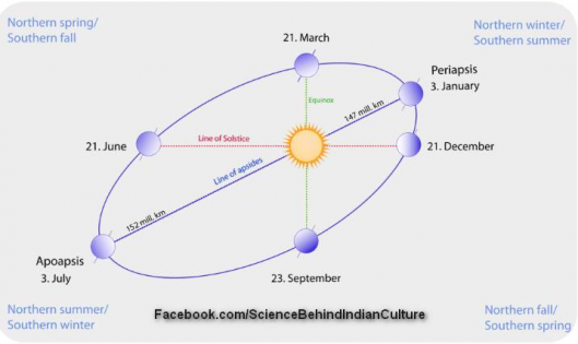
Decoding Neela Bhuvasya using Aryabhata’s codification gives 1050 number i.e the diameter of earth is 1050 Yojanas. It means the diameter of earth is 1050 * 12.2Kms approx = 12810Kms (modern value approx. 12728 Kms). A close match! Now let us see, Tulasidas’ Hanuman Chalisa. It says, “Juga sahasra yojana bhanu“. Juga = 1 mahayuga = 12000 divine years (sum of all yugas in deva years); Sahasra = 1000; Yojana = 12.2 Km; Bhanu = Sun. So, sun is at a distance of 12000X1000X12.2 =146.4million Kms. Modern aprox (nearest point of sun) = 147 million Kms. So, the value is very closely matching.
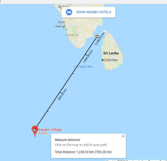
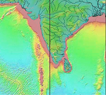
Now let us come to Lanka. Lanka is clearly defined. It was an island and Kubera constructed the city. Kubera constructed it because it was at a very strategic location. It was strategic because, it was at the meeting point of time reference axis (Ujjain – longitude) and equator (latitude). Surya Siddantha says equator passes through Lanka. Now this point is in Maldives. And guess what, if we measure the distance between Rameshwaram and this point, it is very close at 100 yojana = 1238 Kms. Check the image below. Today’s Srilanka was known as “Ceylone” and never in history was called Srilanka.
Probably, Lankans shifted to Ceylone, due to the submerging of their island city. Actual Lanka, where Ravana ruled was probably under sea. As US has taken military position here (island of Diego Garcia) which is also part of this submerged Lanka, they do not want this to be in lime light or researched. Since Puranas, Ramayana and time of Aryabhata, all used the same measure for yojana. There is no point saying, yojana definition was changing in history. It was only British, who confused and reduced the yojana as 1yojana= 5miles = 8Kms. This is just to “fudge” records and snatch away land from Indians. There is no basis for this definition of British yojana.
We do not know which is mount Meru? (some references point it in Himalayas and some to a place in central Asia). So, what Puranas refer and what Aryabhata refer as Meru itself could be different. Considering the height of Everest to be around 9KM, it may not be difficult to imagine a height of 12KM for a “realistic” mountain (may be Everest stood at that height at that time). And what Puranas refer may be a layer above which, it considered as the separation point for earth’s layer with that of Dyuloka or Devaloka. Surprisingly, Planes consider 36000 – 40000 ft as ideal altitude to fly. That is where 100 yojana falls. Since we are talking about yojana in Ramayana times, we do not need to go all the way to Vedas. We can relook at yojana references in Ramayana itself and truth can be determined.
Here is a Ramayana reference to yojana. After visiting the sages Sarabhanga and SuteekshNa, they went to visit sage Agasthya who directed them to spend the rest of the exile in a place called Panchavati, two yojanas down south on the northern banks of the river Godavari. Panchavati means five (pancha) banyan (vata) trees. This is the place where Lakshmana built a bamboo cottage in a tranquil area for Rama and Sita to reside. Considering 1 yojana = 169.25 meters (as some experts feel and interpret it), 2 yojanas – 250 meters, a simple visible distance or 15-20 mins walk. Does such a distance need guidance from Agasthya like, down south and on north river bank etc? To guide a distance of 250 meters, somebody will simply say go this way, you will see 5 vata trees together. So, yojana cannot be such a small distance in Ramayana times. We should not interpret it as a distance between Godavari and Panchavati, wrongly (some experts believe it is the distance between Panchavati and the river and it has to be short to fetch water daily). It is in fact the distance between Agastya’s meeting point and Panchavati. Panchvati was of course constructed close to Godavari river, so that water could be easily fetched daily.
Now let us look at Mahabharatha reference for yojana. By the way, in Mahabharatha Vanaparva, Hanuman narrates Ramayana in summary to Bhima. There also, Hanuman describes he jumped 100 yojanas to reach Lanka. If what Hanuman says and what Bheema understands to be correct, the defination of “Yojana” in Mahabharatha and Ramayana has to be same, Otherwise Hanuman will be converting the distance and will be specifying what it means in Mahabharata time. Since Hanuman says 100 Yojana only, the definition of yojana has not changed between Ramayana and Mahabharatha. So, we need to take, 100 yojanas was valid in Mahabharatha time measure also (since Vyasa is writing the book, he is actually validating this point. Since Vyasa has divided Vedas, it should mean same in Vedas too). There are various instances “yojana” is quoted in Mahabharatha too. For example, in Sabha Parva, “mighty king of Magadha from his city of Girivraja, whirling a mace ninety-nine times, hurled it towards Mathura. At that time Krishna of wonderful deeds was residing at Mathura”. So, Mathura should be a place at a distance of 99 yojanas. Aerial distance between Mathura and Girivraja (Rajgir) is about 820 Kms. By road it measures about 1000 Kms close to 99 Yojana. In no way we can use 340 meters for a yojana here, as that gives a distance of 34Kms between Magadha capital (Girivraja) to Mathura.
So the “Yojana” is validated from Ramayana and Mahabharata references too.
It is difficult to accept, Lanka was in Maldives. It is difficult, because it leads to the conclusion that, “Ravana” really used some kind of “Flying machine” to cross the Indian Ocean. It also means, Hanuman flew 100 Yojana, like superman. Short distance of Adam bridge (between India and Srilanka) is an acceptable conduce. It makes some people to think, Hanuman “swam” or crossed this distance using a “catamaran boat”. That leads to hypothesis that, Hanuman navigated in a boat, but Valmiki fantasized it as a “jum in air”. However crossing 1000 Kms in an open ocean is a remarkable feat and it gives goose bumps (if someone misses Maldives, they go to South Pole with no sight of land in between, and they will not survive, as fresh water will be a problem). These flights of “Ravana” and “Hanuman” are “unexplainable” with current science. So, the main stream scientists want to avoid digging into these aspects. If excavations under the sea around Maldives are taken up, who knows, some archeology findings of submerged “Lanka” could be found.
There are 11 references to yojana in Balakanda itself (Valmiki Ramayana). The very first reference is talking about Ayodhya/Kosala kingdom’s length and breadth. Let us check them to see, if it makes sense to consider a yojana = 12.2 Kms.
Let us start with sloka 1.5.7,
आयता दश च द्वे च योजनानि महापुरी ।
श्रीमती त्रीणि विस्तीर्णा सुविभक्तमहापथा ।।1.5.7।। (Balakanda, Sarga 5, sloka 7)
श्रीमती beautiful and pleasing, सुविभक्तमहापथा well laid out thoroughfares, महापुरी that great city of Ayodhya, दश च द्वे च twelve, योजनानि yojanas, आयता in length, त्रीणि three yojanas, विस्तीर्णा in breadth.
Meaning of Sloka:-
With well laid out thoroughfares, the beautiful and prosperous city of Ayodhya extended for twelve yojanas in length and three yojanas in breadth.
Note the word “MahaPatha” is interpreted here as, “well laid out thoroughfares”. That is a wrong interpretation. “MahaPatha” refers to “MahaPada” => “MahaJanaPada”. Ayodhya was one of the 16 Mahajanapadas from rigvedic times (mandhata Raja story in RV talks about Ayodhya, Sravasti, Kaashi etc).
Rephrased correct meaning:-
With a big city (Ayodhya – Mahapuri), a Length of 12 yojanas (10+2) and a width of 3 yojanas the prosperous Mahapada (Mahajanapada- Kosala) was Beautiful.
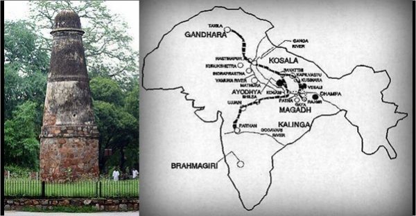
Note:, a popular map of these 16 Janapadhas are given below.
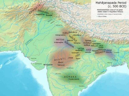
Let us see length and breadth of Ayodhya//Kosala Janapada.. A length of 12 yojana from Ayodhya should put “Sravasthi” in center. Indeed we see that, Sravasthi, which is close to Nepal border comes to center with 12 yojana = 146 Kms.
A width of 3 yojanas = 36.6 Kms. We see 3 Mahajanpadas (Kosala, Malla and Vrij) stretching across middle portion of India-nepal boder. People used to occupy only plain lands, as it is suitable for cultivation. So, the width was narrow for Ayodhya Mahajanapada. The northern border town was “Purandara”, now in Nepal. Due to mountains, the road is curved between Shravasthi and Purandara (even now). This road has to be inside Kosala for people to move without hindrance from neighboring Malla kingdom. This condition was setting the eastern boundary for Kosala. Similarly we can find the boundary between Panchala and Kosala. These limits ensure the width of Ayodhya/Kosala MahaPada was not more than 3 Yojanas (approximately 37 Kms). The Ramayana sloka makes perfect sense.
Let us take 1.6.26,
सा योजने च द्वे भूय: सत्यनामा प्रकाशते ।
यस्यां दशरथो राजा वसन् जगदपालयत् ।।1.6.26।। (Balakanda, Sarga 6, sloka 26)
दशरथ: राजा king Dasaratha, यस्याम् in which city, वसन् living, राज्यम् kingdom, अपालयत् ruled, सा that Ayodhya, भूय: outside, द्वे योजने distance of two yojanas, सत्यनामा worthy of its name, प्रकाशते was shining.
Meaning of Sloka:-
The city where king Dasaratha lived and ruled, spread over a distance of 2 yojanas. And it was worthy of its name.
Rephrased correct meaning:-
With 2 yojana as its outer boundary and truly to its name, it (Ayodhya) was shining. Here King Dasharatha, lived and looked after the people.
Mahajanapadas were centered on a major city (Mahapuri) and one or 2 small cities (For ex, Ayodhya and Sravasti in Kosala). These major cities were identified in the Mahajanapada map (Panchala kingdom- Kampila & Ahichatra, Kashi kingdom- only Varanasi, Magadha – Rajagriha and Pataliputra, etc). The Mahajanapadas (republics were constituted during late Vedic times, after migration from Saraswathi river delta) turned out to be established kingdoms with a king by the time of Ramayana. The major city and kingdom name is used interchangeably. Here Ayodhya is used as a Rajyam or (kingdom) and its circumference (I think it is administrative boundary for tax limits) is defined as 2 yojana. As one number is mentioned with word “Bhooyaha“, it has to be taken as a diameter (distance between any 2 outer security posts).
Note, in 1.5.7, the length and breadth were specified. The whole kingdom itself was 3 Yojana wide, but Ayodhya city (tax limit) was encompassing 2 Yojana. If we interpret 3 yojana as a city width from sloka 1.5.7, then kingdom (rajya as mentioned in 1.6.26) can’t be smaller at 2 yojana. So, the only logic is that, 1.5.7 defines Kosala and 1.6.26 defines city Ayodhya. Ayodhya is referred as “Mahapuri” (question arises about what is difference between puri and mahapuri?). Note, Ayodhya is also called as Saketa. It is possible that the core city with protective walls (a fort) is called Saketa, while the city’s taxable area was called “Ayodhya”.
भरद्वाजाश्रमं दृष्ट्वा क्रोशादेव नरर्षभः।
बलं सर्वमवस्थाप्य जगाम सह मन्त्रिभिः।।2.90.1।।
पद्भ्यामेव हि धर्मज्ञो न्यस्तशस्त्रपरिच्छदः।
वसानो वाससी क्षौमे पुरोधाय पुरोधसम्।।2.90.2।।
– Ayodhyakanda/90/1 has a word “Krosa”. At 1 Krosa, Bharatha stopped his army from Bharadwaja ashrama. Then walks by foot. He explains to Bharadwaja, why he stopped army at a distance (so that army will not disturb the saint’s penance). So, Krosa should be some distance where noise can’t be heard, but also walkable. Around 2 KM is the distance in which the army’s moving noise can be heard (in modern settings like moving tank noise) in silent zones. When great army moves with elephants, a distance similar to that should be considered. So, we can say, Bharatha stopped his army beyond 2Kms periphery of the Bharadwaja ashrama.
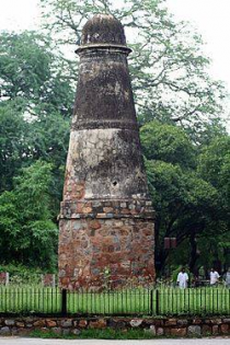
Kos/Krosa Minar; Image source: Wikipedia
Along India’s old highways, particularly the Grand Trunk Road, one still finds 16th to early 18th century Kos Minars, or mile markers, erected at distances of around two miles (around 3 Kms). So, Kos can be taken to be about 3 Kms. 4 Kos / Krosa = 1 Yojana as per Arthasasthra. So, a Yojana will be around 12 Kms, which, tallies with our hypothesis of 1yojana is 12.2 Kms. Since Yojana is a bigger unit than Krosa, Yojana of Ramayana can’t be less than 3Kms.
Ayodhyakanda/
भरतार्धतृतीयेषु योजनेष्वजने वने।
चित्रकूटो गिरिस्तत्र रम्यनिर्झरकाननः।।2.92.10।।
Word Meaning:-
भरत O Bharata, अर्धतृतीयेषु three and a half, योजनेषु yojanas (one yojana is equivalent to eight miles), तत्र there, अजने lonely, वने forest, रम्यनिर्झरकाननः with charming streams and woodlands, चित्रकूटः Chitrakuta, गिरिः mountain (is there).
Meaning:-
O Bharata, three and a half yojanas from here in the lonely forest stands mount Chitrakuta, with its charming streams and woodlands.
We know where is Chitrakuta. Today travel guides say, Bharadwaja ashrama was situated at “Prayaga”/ Alahabad, where Ganga meets Yamuna. But I doubt a ashram close to a very populous place would be established. We also see that, Kausambi was a “MahaPuri” in Vatsa Mahajanapada at that time. So, Kausambi must be a populous town too. It is highly unlikely Bharadwaja ashrama would be situated either at Allahabad or at Kaushambi.
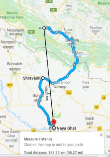
The gurukulas were normally situated deep in the forest, away from noisy human habitation. But due to water requirements, the ashrama must be situated on the “Yamuna’ bank in the direction of Ayodhya. This place, if we see via map will be some where close to “Ajrouli”. That is where Bharatha would have encountered Yamuna river and he needed time to cross it. So, he rested at Bharadwaja Ashrama and sought his guidance to locate Rama. Note, Alahabad or Prayag is not in the direction of “Chitrakoota” from Ayodhya.
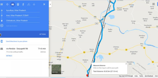
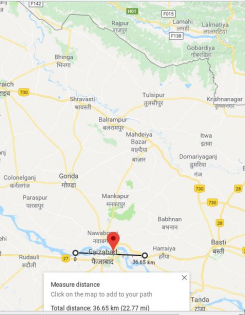
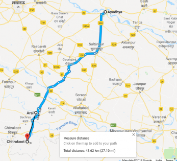
In the Mahajanapada map, we a see a river that was joining Yamuna at Ajrouli (making it a sangama too). That river was the boundary between Surasena and Chedi kingdoms (you can check 16 Mahajanapada map). In Google map we see “Sursena” and “Kausambi” on either side of Ajrouli. Today, river joining Yamuna probably has changed its course or dried up. We only see a road along this path. The distance to Ajouli from Chitrakoota is around 3 and 1/2 Yojana (or about 43 Kms), tallying with what Bbharadwaja says in Ayodhyakanda/92/10.
Featured image courtesy: Wikipedia and harshad30.wordpress.com.
Disclaimer: The views expressed here are solely of the author. My India My Glory does not assume any responsibility for the validity or information shared in this article by the author.
Ramprasad Soghal
Latest posts by Ramprasad Soghal (see all)
Related posts:
 How Ramayana and Mahabharata Symbolize Continuity of Our Civilization
 Toka Siddheshwara Temple with Ramayana Roots; Shivlingam was Installed by Rama
 Tracing Ayodhya to Kekaya Kingdom
 The Concept of Ram Rajya and Good Governance: Lessons from the Ramayana
 Excavated Relics from UP likely to be from Mahabharata Era as per ASI
 Ramayana is True; Why History Needs to be Rewritten to Fill the Missing Gap